Satelytics Announces Breakthrough in Shoreline Management for Georgia Power Using AI-Powered Geospatial Analytics
05 Junio 2024 - 7:00AM

Satelytics, a leader in automated cloud-based geospatial analytics,
today announced the successful results of its ongoing partnership
with Georgia Power, the largest electric subsidiary of Southern
Company (NYSE: SO), America's premier energy company. Satelytics’
advanced AI-powered geospatial analytics technology is helping
Georgia Power to proactively monitor and safeguard the health of
lakes and reservoirs that constitute the organization’s
hydroelectric system, which delivers power to more than 2.6 million
Georgia Power residents in the state of Georgia.
Satelytics deployed a suite of proprietary algorithms, and along
with the field expertise of Georgia Power, was able to proactively
identify threats before they could spiral out of control. The
analyzed images were scheduled by Satelytics and taken with Airbus'
50cm resolution Pléiades 1A/1B satellites, providing unprecedented,
detailed insight into the challenges faced by Georgia
Power—outlining a new approach for the hydroelectric power industry
as a whole.
"Land disturbance issues are the primary concerns we are looking
for with our surveillance program in the lands around the lakes,”
said Dawson Ingram, Lake Resources Manager, Georgia Power.
“Environmental risk is the biggest issue.”
The problems facing the hydroelectric power industry include
shoreline-adjacent private construction projects springing up
faster than manual inspectors can detect them. Soil, pollutants,
and other unwanted debris are at constant risk of draining into
reservoirs. Lakes set aside for water sports, or used as sources of
drinking water, are frequently beset by algae and invasive species,
putting communities at risk. Worse yet, invasive vegetation like
hydrilla can grow to the point of choking off flow into dams, in
the process damaging entire hydroelectric systems. Any one of these
problems, if not identified in time, can cause significant problems
for both hydroelectric power companies and the surrounding
communities.
Satelytics' change-detection algorithms ensured that problems
were identified in time by rapidly detecting land disturbances,
vegetative clearing, and signs of construction on land or at the
shoreline itself. Meanwhile, separate algorithms were deployed to
detect aquatic plant growth in the water, at depths unattainable
with conventional monitoring technology—upwards of two feet in many
cases. Because images were acquired on a seasonal basis, Satelytics
was able to pinpoint subtle differences in terrain, vegetation, and
building structure, and instantly bring these to Georgia Power's
attention for remediation.
"Hydropower is key to a clean energy future, but that future is
jeopardized by threats to the hydroelectic system," said Sean
Donegan, president and CEO of Satelytics. "By drawing multilateral
insights from the highest-resolution imagery, we've been able to
help Georgia Power avoid problems faced by hydroelectricity
projects worldwide, providing the kinds of timely, actionable
information that stops problems at the source."
"Our expertise is taking big data and distilling it down into
critical action alerts and easily digestible data visualizations
for our customers," Donegan continued. "In doing so, we give
Georgia Power and other companies the tools they need to keep
operations running smoothly."
The implications of this project are significant for the
hydroelectric power industry. Georgia Power and its field workers
can save time on remediation efforts by focusing their efforts only
on those issues flagged as most problematic by Satelytics'
technology. This increased efficiency represents a major
breakthrough for an industry whose efforts are crucial for the
future of clean energy and for the country's utility infrastructure
as a whole.
Given the sheer scope of the monitored terrain—and the fact that
many shoreline encroachments are located on, or adjacent to,
private property—the ability of field workers to inspect them can
be very limited. Satelytics, by contrast, is able to regularly
ingest and analyze data and produce actionable results within hours
of capture. These results are delivered in a wide variety of
formats, including text/email alerts and a full suite of
application programming interfaces (APIs) that translate Satelytics
alerts and data into direct input to utility’s existing business
software.
About Satelytics
Satelytics is a software company producing geospatial analytics
for early detection, location and — in many instances —
quantification of our customers’ most pressing challenges. The
Ohio-based company uses science, software and technology to deliver
valuable services to customers to identify problems before they
become disasters – environmentally, financially, or
otherwise. Learn more about Satelytics here.
Media Contact:Michele NachumFirecracker
PRmichele@firecrackerpr.com
Photos accompanying this announcement are available at
https://www.globenewswire.com/NewsRoom/AttachmentNg/6cf44ec6-4bcf-46a2-9d8b-d8e1c98498da
https://www.globenewswire.com/NewsRoom/AttachmentNg/c12891a9-d8c9-440b-adac-f29a0253f342
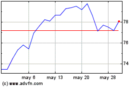
Southern (NYSE:SO)
Gráfica de Acción Histórica
De May 2024 a Jun 2024

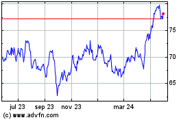
Southern (NYSE:SO)
Gráfica de Acción Histórica
De Jun 2023 a Jun 2024
