VANCOUVER, BC, June 3, 2022
/CNW/ - Zacapa Resources (TSXV: ZACA) (OTCQB: ZACAF) (DE:
BH0) is pleased to announce the completion of its inaugural
drill campaign at its 100% owned Red Top Porphyry copper
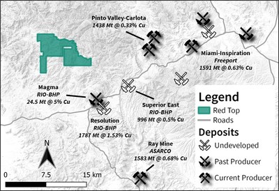
exploration project in the Superior Mining district, 8 kilometers
northwest of Rio Tinto/BHP's Resolution development project.
HIGHLIGHTS
- Original 2-3 hole, 3,000 meter drill program expanded to 6
drillholes and over 5,000 meters following encouraging drill
results, executed safely with zero LTI's, within budget and on
time
- Assays from holes RT-21-001 and RT-22-002 support visual
observations of elevated copper concentrations in a distal porphyry
alteration assemblage
- In accordance with the exploration plan, Zacapa is
transitioning to drilling the South Bullfrog project while awaiting
final results and interpretation from the Red Top drill
campaignZACAF
Initial drilling at the Red Top project has revealed an exciting
new discovery of a quartz monzonite porphyry intrusive cut by
copper-bearing veins occurring in association with low-temperate
quartz-sericite-pyrite (QSP) alteration (see January 26, 2022 news release). This style of QSP
alteration is consistent with alteration peripheral to the center
of a porphyry copper intrusive system and is typically low in
overall copper grade1. Thus the observations from
RT-21-001 displaying copper-bearing veins in association with a
distal alteration assemblage are encouraging, especially
considering that the Resolution copper deposit 8 kilometers
southeast displays copper-rich zones within its QSP alteration
halo2,5. Based on this early success the planned 2-3
hole, 3,000 meter drill program was rapidly expanded to 6 holes and
5,000 meters. The final two holes RT-22-005 (920 metres) and
RT-22-006 (817 metres) were completed in April and May respectively
(Table 1, Figure 1). This expansion of the drill program was done
in conjunction with additional staking, geologic mapping,
hyperspectral remote sensing, and airborne magnetic and MT
geophysical surveys to aid in vectoring towards the core of the
intrusive system (see February 23,
2022, March 10, 2022 news
releases). Porphyry style veins, predominantly with similar QSP
alteration assemblages were encountered over significant
thicknesses in each drill hole with varying abundance of veins
containing copper, lead, zinc, and molybdenum sulfide minerals.
Assay results from RT-21-001 and RT-22-002 have been received and
confirm the presence of elevated Cu, Pb, Zn, Mo, Au, and Ag within
discrete vein sets, although none of the intercepts are considered
to be ore grade x width intercepts that would be considered
economically significant. The presence of copper-sulfides within
the distal QSP alteration assemblage is an encouraging similarity
to the mineral system at Resolution. Assays from the remaining four
drill holes are pending and the full incorporation of all the new
data sets is in progress.
Adam Melnik commented, "the
technical team has done an excellent job of rapidly expanding the
scope at Red Top to fully evaluate the potential of this project
and maximize our time with the available drill rig. We tested a 1.5
× 1.1 × 0.9 km area and encountered veining and alteration
throughout and are looking forward to integrating the abundance of
new data we have available and planning the next phase of work at
Red Top. The team has already begun transitioning to focus on our
upcoming drill program at our South Bullfrog project while we wait
for final results and interpretation of the Red Top drill
campaign."
|
DRILL
HOLE ID
|
EASTING
|
NORTHING
|
ELEVATION
(m)
|
AZIMUTH
(°)
|
INCLINATION
(°)
|
PLANNED
DEPTH (m)
|
FINAL
DEPTH (m)
|
|
RT-21-001
|
489107
|
3692695
|
1,063
|
60
|
-60
|
800
|
1,042
|
|
RT-22-002
|
489588
|
3692518
|
1,098
|
60
|
-75
|
800
|
779
|
|
RT-22-003
|
488970
|
3693022
|
1,060
|
90
|
-65
|
800
|
986
|
|
RT-21-004
|
489034
|
3693577
|
1,100
|
275
|
-60
|
500
|
623
|
|
RT-22-005
|
489002
|
3692896
|
1,070
|
275
|
-80
|
1,200
|
920
|
|
RT-22-006
|
490058
|
3692591
|
1,200
|
45
|
-70
|
800
|
817
|
Drill Hole
Descriptions
Drill Hole
RT-22-005
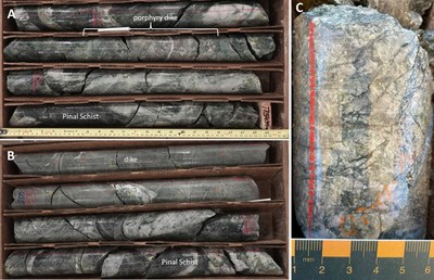
Drill hole RT-22-005 was collared approximately 140 metres south
of RT-22-003 and drilled to a total depth of 920.4 meters (Table
1). The hole was drilled to test the hydrothermal system at
depth and further west of prior drilling to assist in vectoring
toward the associated porphyry center. RT-22-005 collared into
Pinal Schist which continued to approximately 80 metres downhole
and was cut by a number of granitic porphyry dikes. Below this the
drillhole cuts variably phenocryst-rich quartz monzonite to granite
porphyry intrusions with minor xenoliths of various lithologies,
most prevalent near the end of hole. The schist contains weak to
moderate chlorite and magnetite alteration of mafic minerals and
the granite porphyry is characterized by a weak sericite
replacement of felsic phenocrysts and weak chlorite alteration of
mafic sites. Traces of epidote alteration are also present within
the granite porphyry particularly around miarolitic cavities and as
irregular patches within diabase xenoliths. Sericite halos are
common around chlorite-sericite and quartz-chlorite-sericite veins
ranging from 0.1-5 cm in width. The veins are most prevalent, with
average densities of 5%, in the upper half of the drill hole, after
which the vein density decreases significantly to less than 1%.
Locally vein densities are well over 10% with well developed
quartz-sericite-pyrite envelopes (Figure 2). Sulphide
mineralization in RT-22-005 includes pyrite ± chalcopyrite ±
bornite hosted in quartz-chlorite-sericite veins and pyrite ±
chalcopyrite ± bornite ± sphalerite ± galena hosted in open space
quartz-barite-fluorite veins and disseminated magnetite ± pyrite.
Magnetite is present in all lithologies and tends to occur as small
veinlets (Figure 3a) and as disseminations.

Drill Hole RT-22-006
Drill hole RT-22-006 was collared approximately 1.2 km east of
RT-22-005 and drilled to a total depth of 816.8 meters (Table 1).
The hole was designed to test a large conductivity anomaly
identified in the Mobile MT geophysical survey located NNE of the
collar. RT-22-006 collared into Pinal Schist which continued
throughout the hole and was locally cut by diabase, diorite (Figure
3), and quartz monzonite dykes. The schist contains weak to
moderate chlorite and sericite alteration of mafic and felsic
minerals, respectively, often associated with fracture zones. Veins
are dominantly trace to weak chlorite-sericite-pyrite in the upper
600 meters, increasing to 1-5% from 585 to 770 metres with lesser
quartz-sericite-pyrite veins. From approximately 770 metres to
end-of-hole quartz-sericite-pyrite veins dominate with abundances
from 1 to 4%. Open space quartz-barite-fluorite ± base metal veins
occur from 140 to over 800 metres. Vein densities in this hole were
dominantly 2% and locally up to 10%. Sulphide mineralization in
RT-22-006 includes pyrite ± chalcopyrite hosted in
chlorite-sericite veins, pyrite ± chalcopyrite hosted in
quartz-sericite veins, pyrite ± chalcopyrite ± sphalerite ± galena
hosted in open space quartz-barite-fluorite veins and disseminated
magnetite ± pyrite.

About the Red Top Porphyry
Copper Project
The Red Top porphyry copper project is located in the Superior
Mining District, 8 kilometres northwest of the Rio Tinto and BHP's
Resolution mine development project and approximately 11 kilometres
from the Carlota and Pinto Valley mining operations. Red Top is
comprised of 431 unpatented mining claims covering 8,377 acres. The
Red Top project area exhibits widespread porphyry style alteration
with locally intense alteration spanning approximately 3.5
kilometres by 1.5 kilometres. These intensely altered areas of
quartz-sericite, as well as zones of pyrophyllite and illite are
analogous to assemblages associated with mineralization at the
upper levels of the Resolution deposit2,3,4. This
alteration and mineralization at Red Top are interpreted as the
expression of the upper levels of a now moderately tilted porphyry
system that has only seen limited historical exploration and no
previous drilling within the target area. Zacapa is one of the only
exploration companies drilling for porphyry copper in southeast
Arizona, which is dominated by
Freeport, BHP and Rio Tinto.

About Zacapa
Resources
Zacapa is a copper and gold focused mineral exploration company
engaged in responsible exploration for the new energy economy. Its
projects are concentrated in world class jurisdictions in the
southwest U.S., including Arizona,
Nevada, and Idaho. The
portfolio includes porphyry copper projects at Red Top, Pearl, and
Dewdrop Moon, and epithermal gold projects at South Bullfrog and
Miller Mountain. These assets are
being advanced by a highly disciplined and seasoned professional
team with successful track records of discovery, resource
development and mine permitting.
References
|
1
Halley, S., Dilles, J.H., and Tosdal, R.M., 2015, Footprints:
Hydrothermal alteration and geochemical dispersion around porphyry
copper deposits: Society of Economic Geologists Newsletter, no.
100, p. 1, 12-17.
|
|
2
References to other mines and deposits made in this news release
provide context for the Red Top Project, which occurs in a similar
geologic setting, but this is not necessarily indicative that Red
Top hosts similar grades or tonnages of
mineralization.
|
|
3
Manske, S.L., and Paul, A.H., 2002, Geology of a major new
porphyry copper center in the Superior (Pioneer) district, Arizona:
Economic Geology, v. 97, no. 2, p. 197-220.
|
|
4
Rio Tinto, 2020, Annual Report:
https://www.riotinto.com/invest/reports/annual-report
|
|
5
Paul, A.H., and Manske, S.L., 2005, History of exploration at
the magma Mine, Superior, Arizona, in Rhoden, H.N., Steininger,
R.C., and Vikre, P.G., eds., Geological Society of Nevada Symposium
2005: Window to the World, Reno, Nevada, p. 629-638.
|
|
6 Singer, D.A., Berger,
V.I., and Moring, B.C., 2008, Porphyry copper deposits of the
world: database and grade and tonnage models, 2008: U.S. Geological
Survey, Open-file report 2008-1155,
https://pubs.usgs.gov/of/2008/1155/.
|
|
7 Dicken, C.L., Dunlap, P.,
Parks, H.L., Hammarstrom, J.M., and Zientek, M.L., 2016, Spatial
database for a global assessment of undiscovered copper resources:
U.S. Geological Survey Scientific Investigations Report
2010–5090–Z, 29 p., and GIS data, available at
http://dx.doi.org/10.3133/sir20105090Z.
|
For more information, please visit www.zacaparesources.com. All
documents are available on Zacapa's profile page on SEDAR at
www.sedar.com.
On behalf of the Board of Directors,
"Adam Melnik"
All scientific and technical information contained in this
press release was prepared under the supervision of
Daniel MacNeil, MSc., P. Geo.,
and a "Qualified Person" as defined by National Instrument
43-101.
Neither the TSX Venture Exchange nor its Regulation Services
Provider (as that term is defined in the policies of the TSX
Venture Exchange) accepts responsibility for the adequacy or
accuracy of this release.
Forward Looking Statements – Certain information set forth in
this news release may contain forward-looking statements that
involve substantial known and unknown risks and
uncertainties. All statements within, other than statements
of historical fact, are to be considered forward looking. Although
Zacapa believes the expectations expressed in such forward-looking
statements are based on reasonable assumptions, such statements are
not guarantees of future performance and actual results or
developments may differ materially from those in forward-looking
statements. Zacapa cautions that all forward-looking statements are
inherently uncertain and that actual performance may be affected by
a number of material factors, many of which are beyond Zacapa's
control. Accordingly, actual and future events, conditions and
results may differ materially from the estimates, beliefs,
intentions and expectations expressed or implied in the
forward-looking information. Readers are advised to rely on their
own evaluation of such uncertainties. Except as required under
applicable securities legislation, Zacapa undertakes no obligation
to publicly update or revise forward-looking
information.

SOURCE Zacapa Resources